GPS Remote Monitoring Systems
Hitachi Zosen has developed a GNSS (Global Navigation Satellite System) ocean buoy. These buoys have been installed by the Ministry of Land, Infrastructure, Transport and Tourism since 2005. Currently, 18 of the buoys are installed in Japan.Following the Great East Japan Earthquake, tsunami wave heights were observed not only by the GNSS ocean buoys installed in the Pacific Ocean off the coast of Tohoku, but also by the GNSS ocean buoys installed off the coasts of Tokai, Kinki, and Shikoku.The GNSS ocean buoy was the first in the world to observe tsunamis offshore in real time. The buoy is now attracting attention throughout the world, including in Chile, Indonesia, and other countries affected by tsunami. The GNSS ocean buoy is expected to contribute to tsunami disaster prevention in various countries around the world.
Major products
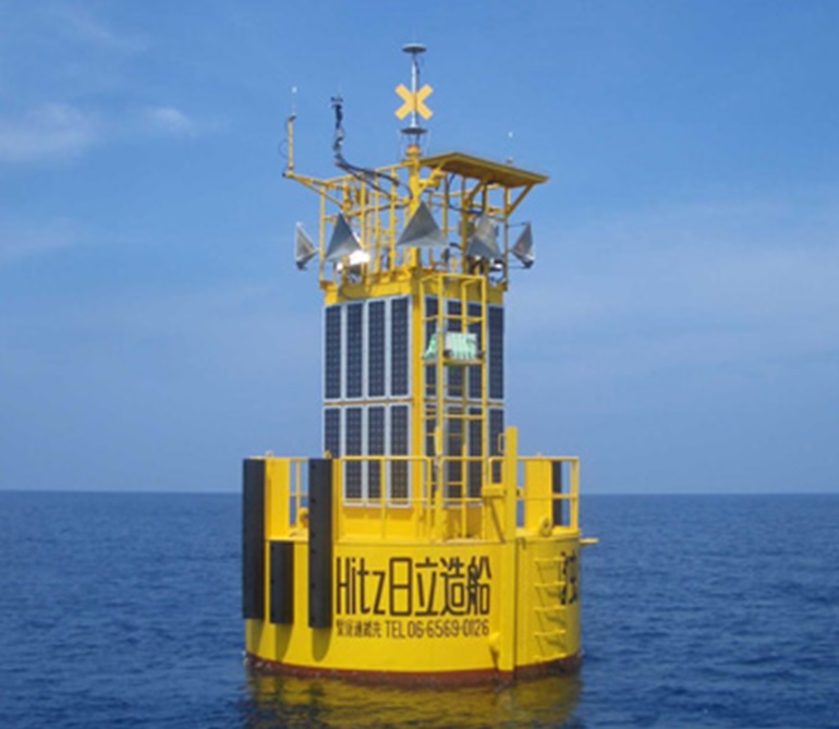
GNSS ocean buoy
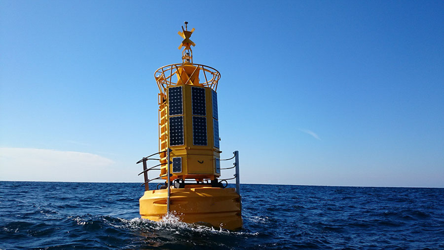
A GNSS antenna is mounted on the top of the buoy and the sea level is measured in real time using satellite positioning data. The buoy has a structure that can withstand harsh sea conditions such as typhoons. It holds its position by anchors and mooring lines installed on the seafloor. The power required for lighting equipment and monitoring is supplied by solar power generation. Remote monitoring is used to check the temperature and humidity inside the buoy, as well as to determine the presence or absence of water leaks.
- Delivery record: 20 units for use in Japan (including updating for 1 unit)
Observation monitoring system
Measurement results obtained from GPS ocean buoys, multifunctional observation buoys, etc., can be filtered to observe short-period waves to long-period tide levels.
GPS Remote Monitoring Systems
In order to observe crustal movements with millimeter accuracy, Hitachi Zosen is involved in the construction, maintenance, and operation of electronic reference point network facilities and real-time continuous observation systems of the Geospatial Information Authority of Japan. We provide highly-accurate displacement monitoring technology and services with the goal of realizing a society in which satellite positioning and geospatial information can be utilized in an advance manner.
Furthermore, Hitachi Zosen is developing technology for real-time measurement of position of the earth's surfaces and tides with high accuracy even over ultra-long distances (about 1,000 km). We will utilize this technology in the fields of disaster prevention and the ocean.
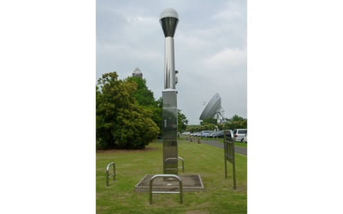
GPS continuous observation system
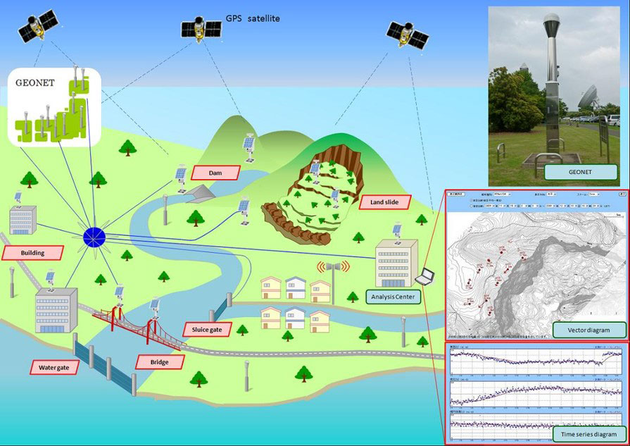
Hitachi Zosen provides systems which combine position measurement results and various information management algorithms. These systems are used to monitor changes in ground and crustal movements that are effective in predicting earthquakes and landslides, and to monitor changes in the position of structural displacement (infrastructure equipment such as roads, bridges, sluices, dams, and embankments).
Main fields of application
Disaster prevention, disaster mitigation, safety, security, construction, civil engineering, surveying, environment
Features
Automatic data collection and automatic analysis, high-precision position measurement, wide range of result display screen
Real-time analysis software

This is a real-time analysis software with various analytical functions. In addition to the coordinate values, it is also possible to output the troposphere, ionospheric delay amount, etc. This enables us to construct systems that match the usage scenes.
Main fields of application
Disaster prevention, disaster mitigation, safety, security, construction, civil engineering, surveying, environment
GNSS Precipitable Water Data Service
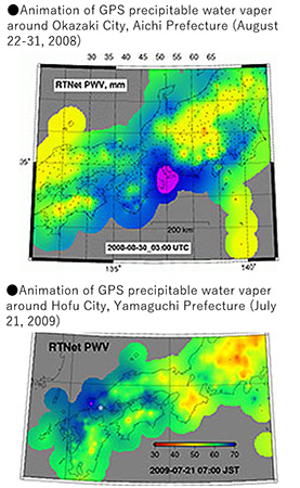
Hitachi Zosen uses the GNSS observation network to provide the results of analysis for the amount of water vapor in the sky before it falls on the ground. This technology is used in response to localized heavy rains, such as the torrential rainstorms which recently occur with high frequency in Japan.
Features
Providing precipitable water data in real-time or historical data
Data is provided in three forms: 60-minute value, 30-minute value, and 10-minute value.
GNSS Precision Correction Data Service
By utilizing real-time data of the electronic reference point network, Hitachi Zosen calculates precise satellite orbits, clocks, etc., and provides them as GNSS correction data required for GNSS precision analysis.
By using our GNSS analysis software RTRover, data can be used for PPP-AR position measurement, atmospheric delay measurement, etc. This means that data can also be used for precise position measurement in coastal areas and estimation of precipitable water for weather prediction.
Main specifications
| Item | Contents |
|---|---|
| Corresponding satellite | GPS, GLONASS, Galileo, QZSS |
| Method of provision | Real-time (TCP/IP method) Post-processing (FTP, DVD media) |
| Target area | Within Japan (excluding remote islands) and up to 1,000 km off the coast |
| Included information | Satellite orbit, satellite clock, satellite antenna bias |
Related technology

Click here for inquiries about Hitz technology